From Wikipedia, the free encyclopaedia:
The All Saints' Flood of 1170 (Allerheiligenvloed) was a catastrophic flood in The Netherlands. Large parts of the Northern Netherlands, and Holland territories were overflowed. This is the flood that made the Zuider Zee. "Lake Flevo" was once a fresh water lake, but after this flood a sea channel opened a connection from the North Sea into the lake through 'Creiler Forest', and turned the lake into the salt-water sea known as the Zuider Zee. The Creiler Forest vanished forever beneath the waves.
 Creiler Forest around the year 1100. The exact position of the forest is unknown
The sea area increased inside the The Netherlands and large peat areas developed, which were easily washed away.
St. Lucia's flood (Sint-Luciavloed) was a storm tide that affected the Netherlands and Northern Germany on December 14, 1287 (the day after St. Lucia Day) when a dike broke during a storm, killing approximately 50,000 to 80,000 people in the fifth largest flood in recorded history.
Much land was permanently flooded in what is now the Waddenzee and IJsselmeer. It especially affected the north of the Netherlands, particularly Friesland. The city of Griend was almost completely destroyed, only ten houses were left standing. (Griend now:
http://en.wikipedia.org/wiki/Griend )
The name Zuiderzee dates from this event, as the water had merely been a shallow inland lake when the first dikes were being built, but rising North Sea levels created the "Southern Sea" when floods including this flood came in.
Victims
The exact number of casualties is unclear, but some sources mention 30.000 deceased victims between Stavoren and the Lauwers

and another 20.000 from the Lauwers to the Eems. Based on these accounts the estimate for the entire region struck by this flood is from 50.000 up to 80.000 casualties. This made the Saint Lucia flood, in relation to the total number of inhabitants of the Netherlands in that period (about 500.000) the largest storm flood of all times ever in the Netherlands. And makes it the 5th largest flood disaster of all times world wide.
* Map of the Netherlands in Roman times:

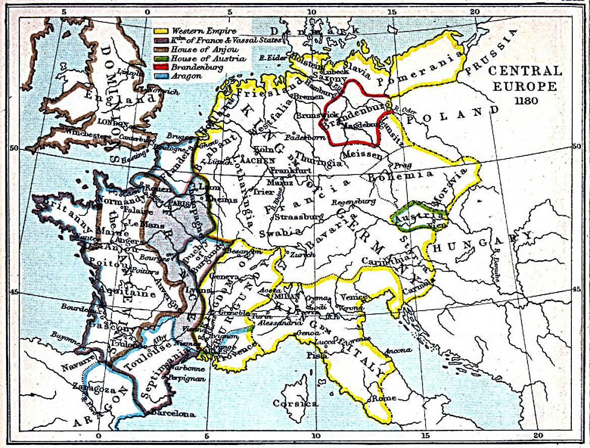
* Map of Central Europe in 1180 AD (pre flood)
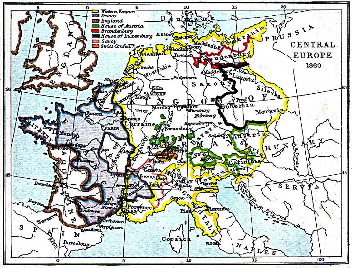
* Map of Central Europe in 1360 AD (post flood)
History of the Netherlands:
http://en.wikipedia.org/wiki/History_of_the_NetherlandsOn the right there is large list of links to more details about all kinds of things, language, peoples, migration etcetera.
I live in the far North of the country, on the island AMELAND:
http://en.wikipedia.org/wiki/Ameland 
<--- The yellow marker is on the roof of my house.
Coordinates: 53°26'40.85" North and 5°46'35.97" East (To look it up in Google maps or Google Earth)
After WW II, (which ended a little later here on the island due to the fact that the Canadians didn't have time to come and get he German soldiers.

)
the island's economy started to turn to tourism. Before it was mainly agricultural (dairy) , fishing and sailing. During the 17th and 18th century many men from this island were sailors with the VOC and commanders on the whaling fleet.
The name of the street I live is reminding of those days: "Commandeursstraat" which means "Commanders street". The streets that cross this one have the names of those commanders: "Hans Jochem" "Obbe Edskes"
They earned a lot of money and were able to build good houses, luxurious for that time. Many are still standing and well preserved.
During the summer months there are about 35.000 to 45.000 tourists on the island, in the winter we have the island to ourselves, some 3500 people in all.
I feel very lucky to be able to live in this little paradise. It's a birder's dream, because it is situated on one of the major bird migration routes.
Life is so much more relaxed here, probably because we are separated from the craziness of the mainland by water and always have that 45 minutes on the ferry to get to and from the island.
In Nes, the village I live in, there is a wonderful church, built by Pierre Cuypers
who was also the architect of the Rijksmuseum in Amsterdam.


 I LOVE learning these kinds of things!
  for sharing your culture!